Wednesday 1 November 2023

The Vajont Dam Disaster, Sixty Years On


Vajont is located about 100 km due north of Venice in the eastern extension of the Italian Dolomite Mountains, a part of the Alpine arc. It is also situated on the boundary between the Italian regions of Veneto and Friuli Venezia-Giulia. The Vajont valley is an eastern lateral tributary to the Piave River, which flows into the Adriatic Sea northeast of the Venetian lagoon. The area is renowned for the First World War battles that were fought at various locations there.

In the late 1950s, SADE, the regional hydroelectric company, prepared to build a dam on the Vajont stream. The location, close to the outlet of the valley, was chosen because it was the site of a deep, V-shaped defile in hard rock. The structure was to be a double-arched concrete dam built up with pre-cast concrete blocks. A double-arched structure throws the pressure at the upstream side of the dam onto the shoulders of the valley and can thus be a very strong solution that resists destruction by exceptional forces. The intended purpose of the dam was to regulate the flow of water to electrical turbines on the Piave River by ensuring a supply at times when the main river was at low flow.

During the construction of the dam a sizeable landslide occurred in the valley upstream. Upon completion, at 262.5 metres from floor to rim, it was the highest concrete arch-dam in the world. In 1960, as the water began to be impounded, there was a 700,000 cubic metre landslide into the reservoir on the south side, which is dominated by the vast bulk of Mount Toc. Various measures were taken to monitor and control slope stability, but they proved ineffective. On 9th October 1963, at 22:39 local time, a 240 million cubic metre landslide dashed into the reservoir from the flanks of Mount Toc, travelling at about 100 km/hr.

The mechanism of the Vajont landslide has been vigorously debated ever since. It was a sturzstrom, according to the term coined in 1930 by the eminent Swiss geologist Albert Heim. At the time only about 60 examples of sturzströme had been documented in the world. The phenomenon was controversial and poorly understood. Essentially, the larger the moving mass, the lower the basal friction, which is counter-intuitive in terms of basic physics. The Vajont landslide slid as a sort of gigantic mattress on a smooth plane of rock.

The material cascaded into the lake and produced a water-wave 180 metres high which climbed the opposing slope of the valley and obliterated the hamlet of Erto, as well as damaging a few houses in Casso, located further up the slope. Frantic efforts had been made to reduce the water level behind the dam, but it was only about 30 metres below the lip. The landslide-generated wave was about 100 metres high as it abruptly changed direction from northwards to westwards. It was thus 70 metres high as it gushed into the Piave valley straight towards the town of Longarone. It obliterated the town, with the exception of very few buildings located at some distance from its centre. The wave then roared down the Piave valley, destroying eleven small settlements as it went. At Vittorio Veneto, 44 km away, it was still six metres high.

Some 1,917 people were killed, most of them instantly, by the water wave. The dam survived with minor damage to its rim. The reservoir ceased to exist, as it was now filled with rock debris from the landslide. A small lake survives to this day 2 km upstream. Longarone was rebuilt, largely by emigres who returned from working abroad and elsewhere in Italy. The dam remains as a sombre monument to the disaster. It is visible from Longarone and its environs in the Piave valley.

In essence, the disaster was caused by a series of bad and unsustainable decisions about the stability of the Alpine landscape in the Vajont valley. The strata on Mount Toc are, to use a useful Italian term, a franapoggio, orientated in the direction of the slope in a way that provides a ready slip surface for overlying material. There were low-strength zones at depth. Filling the reservoir increased the pore-water pressure at the base of the slope, which decreased its strength. Finally, as subsequent research has revealed, sturzströme are not uncommon in the Alps.

Over the years after the disaster, a constant stream of geologists and engineers visited the site, which remained largely undisturbed, forlorn and peaceful in its terrible grandeur. It is particularly awe-inspiring in the cold, grey light of winter. A memorial park, mass-burial cemetery and two chapels were constructed. Marble tablets at the access tunnel to the dam commemorated the loss of life. In Longarone a documentation centre and small museum were built, along with a civil protection training centre.

Recently, the site of the disaster has been opened up to tourism, with a visitor centre, guided tours and a protected walkway across the rim of the dam. The valley has begun to lose its air of abandonment and isolation. Moreover, on the evening of the 60th anniversary of the disaster (9th October 2023), 170 theatres in Italy held manifestations, plays and readings, with a collective pause at the moment of the tragedy, 22:39 hrs. This was specifically designed to keep the memory alive and help people who are too young to have lived at the time of the disaster to know about it. The theatre performances drew upon a rich heritage of books, studies, memoirs, plays and music that over the years has commemorated the Vajont tragedy. There is also a major cinema film about the disaster, with spirited performances by actors representing the main protagonists, including the engineers and geologists involved in planning and designing the reservoir and dam.

In the aftermath of disaster there is often a tension between those who want to commemorate the event and those who want to forget it, or to obscure the memory. For example, in Lombardy 200 km away from Vajont lies the Stava valley, where in July 1985 the collapse of two mine tailings dams led to a mudflow which killed 264 people. For years, efforts to create a documentation centre and memorial at the site were routinely blocked. At the other end of the scale, in the Tōhoku region of northeast Honshu, Japan, there are now 62 museums dedicated to the March 2011 earthquake, tsunami and nuclear release. For better or worse, this is an area in which disaster tourism has come to stay.

Surely we would all agree that to avoid repeating errors of response and mitigation it is important to learn the lessons of disasters, and that in order to do so we need to keep the memory of such events alive. Yet researchers have also described a phenomenon called 'dark tourism', which tells us that people can have good or bad motives for wanting to visit the sites of past disasters. This is a complicated matter, as it is difficult to define what is good and what is bad. Nevertheless, some of the 'disaster tourists' may be mere sensation seekers while others are motivated by a more noble desire to learn and to confront the realities of life.

With 60 years of hindsight, it is very clear that a large reservoir dam should never have been built at Vajont and that the tragedy resulted from appalling negligence in allowing that to happen in an area of steep, unstable slopes, fractured geological formations and a highly exposed population. A remarkably similar disaster had occurred in France in 1959 with the collapse of the Malpasset dam and the loss of 423 lives. Once again, superficial geological and geotechnical survey work was at the heart of the calamity. Unfortunately, similar tragedies have continued to occur (witness the Derna, Libya, dam collapses of September 2023) and have sometimes been narrowly averted (as in the Whaley Bridge, Derbyshire, emergency of August 2019, which necessitated the evacuation of 1,500 residents from downstream. On balance, it is useful, not only for us all to hear these stories, but for us all to think carefully about what they mean in terms of human safety in the future.

 

Thursday 14 September 2023

The real burden of risk


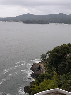
                       A piece of the Sanriku coast at Minamisanriku, NE Japan.
                       In 2011 there was a 20.5-metre tsunami here.

In 1966 the eminent Californian risk analyst Chauncey Starr published a seminal paper in Science Magazine in which he stated that "a thing is safe if its risks are judged to be acceptable." In effect, he built his reputation on the premise that the acceptability of risk is arbitrary.

Before I travel on university business I am required to fill in a complicated on-line form called a risk assessment. Recently, I had to do this before attending a series of meetings in Japan. By and large, Japan is a very safe country in which to travel and sojourn. By contrast, where I live in north London, within a radius of 400 metres of my front door, there have been at least two murders, a major and lethal terrorist incident, an international terrorist conspiracy, a series of road accidents, some of which were fatal, episodes of chronic pollution and overcrowding, and a constant battle between the police and a well-organised, wide-reaching drug supply ring. In the 1950s the area was immortalised in the photographs of Don McCullen, who was attracted by the presence of the London mafia.

When I travel from north London to my university I use public transport, which is of variable reliability. I then have to cross a busy four-lane arterial road. At one point the green light allows five seconds for pedestrians to scoot across, while at another designated crossing place they are afforded no protection at all against the streams of roaring traffic. At my university a problem with vibrating equipment caused bouts of deafness and nausea, and for various reasons it was two years before something was done about it. We then discovered that our dilapidated teaching rooms were lined with asbestos and the university was not aware of its presence. For none of this was I ever required to fill in a risk assessment form.

According to the set procedure for funded travel, I need to assess the risks of being in Japan. In cities a car cannot even cross a pavement without the presence of one or two uniformed characters waving flags to alert passers-by. For crossing roads, Japanese urban designers afford pedestrians the same status as traffic, with ample margins of time, wide crossings and perfect signage. I was once in a coffee bar in Japan when there was a magnitude 6.8 earthquake. Elsewhere it might have caused major devastation; in Sendai, people in the coffee bar did not even stop reading their newspapers.

A colleague who intended to do fieldwork in Turkey was required to produce a personal evacuation plan to be used if there were a major earthquake. Clearly, such a plan would be immediately invalidated by disruption to normal transportation schedules. Now if a repeat of the 1923 Kanto earthquake were to occur while I happened to be in Tokyo, I doubt very much whether the risk assessment would help me. I would have to resort to awareness and common sense.

Despite these musings, risk assessment is, of course, not useless. The problem is that procedural rigidity constrains us to use methods for harmless travel that are the same as those that apply to dangerous experiments and surgical operations. No doubt if I were travelling in eastern Ukraine or Yemen I would dedicate myself more willingly to considering the risks, but not for places where risk assessment effectively cannot help.

The possible solution to this state of affairs would be to divide risk assessment into two. For genuinely risky enterprises the approach would be technical and scientific. The odds of a mishap would be calculated and, where possible, reduced. For un-risky work, a different approach is needed. In this case, the principal value of risk assessment is to ensure, as far as possible, that the university is not sued. Perhaps, then, we should leave it to the lawyers to fill in the forms.

If, gentle reader, this diatribe should strike you as being mere petty complaining, please consider the wider implications, those beyond the shadow of lawsuits and injuries (however faint that shadow may be). Our principal motivation for being academics is to exercise our creativity. However, before collecting data we need data protection registration, ethical approval, deposition of itineraries, risk assessments and more. As we all know, similar bureaucratic loads apply to teaching. The effect of all this form-filling-in is to sap our creativity. Colleagues complain to me that they lack the energy to do real academic work after a day of grappling with poorly designed software intended to collect information that no one really wants, or dealing with procedures that merely add another layer of complexity to what was once a simple, refreshingly human activity.

We watch with alarm at the way bureaucracy grows unstoppably in our universities, how processes that are ostensibly designed "to make our work easier" are instead piling on the burden. And, of course, no one in the university has ever conducted a risk assessment of the impact of the bureaucracy!


Thursday 3 August 2023

The United Kingdom's National Risk Register - 2023 Edition


At the time of writing this, the UK Government has just released the 2023 edition of the National Risk Register (NRR, HM Government 2023). This document was first published in 2008 and has been updated (somewhat irregularly) at roughly two-year intervals. The new version presents 89 major hazards and threats that could potentially disrupt life in the United Kingdom and possibly cause casualties and damage.

Over the years this document has acquired momentum based on a solid commitment to persist with it and create periodic revisions. It is the public face of the National Security Risk Assessment (NRSA), a document (and a process) that has various security classifications and is generally not available to citizens and organisations. The current version of the NRR draws more on the NRSA than did previous versions. In this, the UK Government is honouring its promise to promote greater transparency in risk assessment.

The first edition of the NRR was a pioneering document that has been emulated by a variety of other countries. It makes sense to enunciate the major risks that a country faces so that all citizens can be clear about what needs to be tackled in terms of threats to safety and security in the future. The 2023 NRR is clear and concise. It explains its own rationale and presents the 89 'risks' one by one.

Although the NRR is certainly a valuable--and many would say necessary--document, it has some drawbacks.

(a) As noted by the House of Lords Select Committee on Risk Assessment and Risk Planning (House of Lords 2021), the NRR is not very "user-friendly" and is not well-known. One hopes that the latest version will reach a wider audience of citizens and organisations that did the previous editions.

(b) In terms of its methodology, the NRR discusses vulnerability but does not accept the premise (Hewitt 1983) that it is the major component of risk. Hence, the risk register largely discusses hazards and threats, not risks sensu stricto.

(c) The register uses a two-year assessment period for malicious risks and a five-year period for others, but many risks that threaten the UK will be evolving over a longer period. It therefore does not consider how risks are likely to evolve in the future. This is particularly important for those hazards associated with climate change. The register is thus not well connected to the foresight programme run by the UK's Government’s own Office for Science.

(d) The NRR does not consider risks as ensembles, despite the fact that they frequently materialise in groups. For instance, the NRR presents widespread infrastructure failure as a risk, but  if it were to occur, it would probably be the result of another hazard or threat such as a major storm or a successful cyber attack. This is a simple example: others are more complex, but the intricacies do need to be confronted.

(e) The risks are prioritised by giving most weight to those associated with hostile activity. In reality, it is at least equally likely that the major burden the UK will have to bear will involve natural hazards such as storms, heatwaves, wildfire or cold and snow. In the new version of the NRR natural hazards are given shorter descriptions and less prominence than that attributed to hostile risks.

(f) As a result of the previous two points, it is difficult to turn the risks, as they are described, into planning scenarios. This is a pity as it could be the NRR’s greatest source of utility.

The UK National Risk Register is allied to a number of other documents. One of these is the National Resilience Framework (HM Government 2022). This document has the merit of setting goals and targets for the achievement of resilience in Britain. However, it has serious weaknesses. For example, it makes no mention of gender, ethnic minorities and people with disabilities. That is most unfortunate because it is here that the efforts to create resilience need to be concentrated.

The 2023 National Risk Register has made some progress in responding to criticisms of the previous versions, but it could have made much more. As risk is largely a function of vulnerability, this fact needed to be acknowledged, rather than concentrating entirely on hazards and threats. There is no geographical dimension, which avoids the question of what size events are likely to be and whether certain parts of the country, and certain groups of citizens, would be most at risk.

The scenarios of risks described in the register are mostly described in 100-200 words. They are restricted to the "plausible worst-case" (which is usually a highly debatable concept). One great paradox here is that the worst effects may not necessarily come out of the worst impact. More reflection is needed.

The United Kingdom does not have a proper civil protection system. What it does have is fragmentary, confusing, overcomplicated and in places amateurish. This is a great pity as there is no shortage of expertise in the country. As I said in the witness box of the UK Covid Inquiry earlier this year, given the question "within the limits of what a government can, and should, achieve, does the UK Government keep citizens safe?", my answer is "no".

References

Hewitt, K. (ed.) 1983. Interpretations of Calamity from the Viewpoint of Human Ecology. Unwin-Hyman, London: 304 pp.

HM Government 2022. The UK Government Resilience Framework, December 2022. UK Government, London, 79 pp.

HM Government 2023. National Risk Register 2023 Edition. UK Government, London, 191 pp.

House of Lords 2021. Preparing for Extreme Risks: Building a Resilient Society. Report of Session 2021-22. HL Paper no. 110. Select Committee on Risk Assessment and Risk Planning, House of Lords, London, 127 pp.